 click to enlarge
 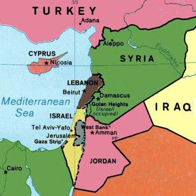 click to enlarge
 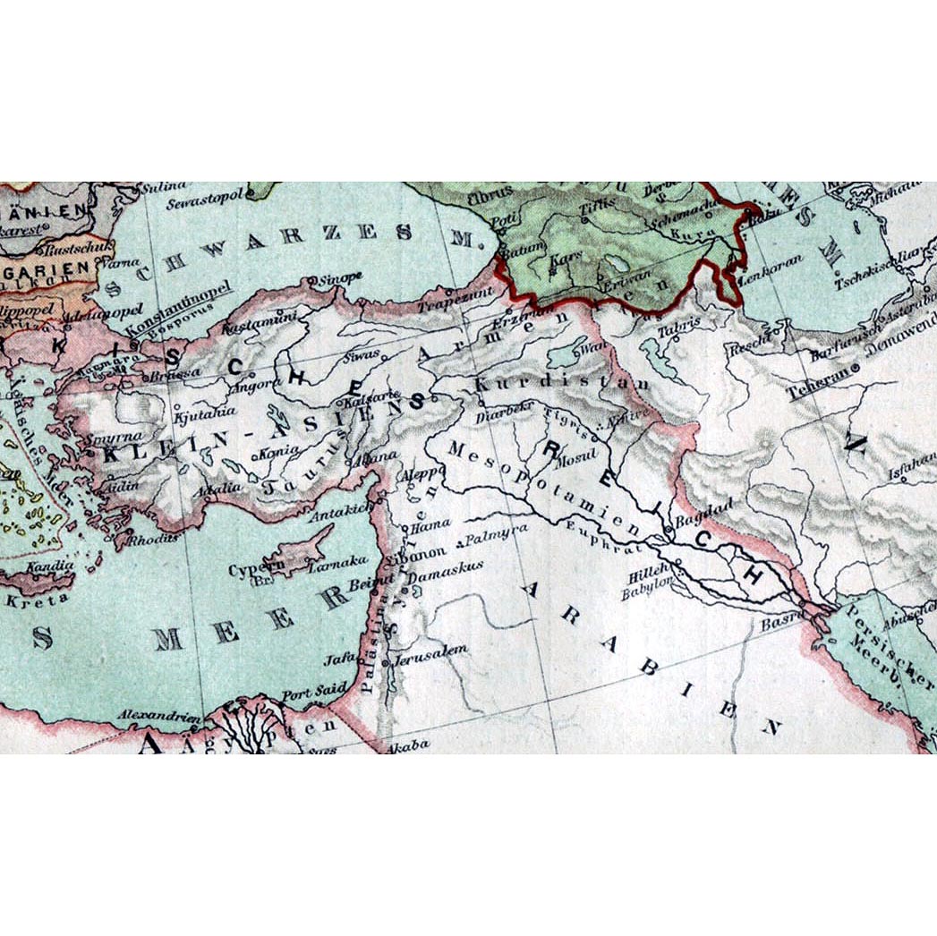 click to enlarge
  click to enlarge
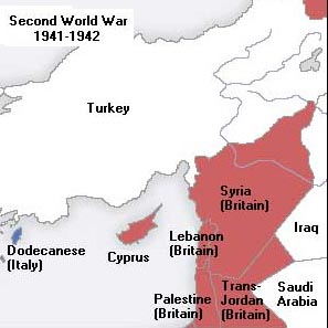
 click to enlarge
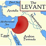
 click to enlarge
  click to enlarge
  click to enlarge
 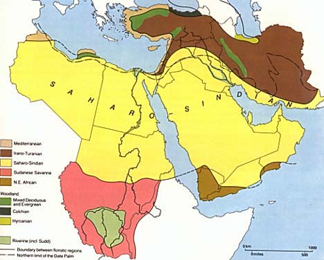 click to enlarge
 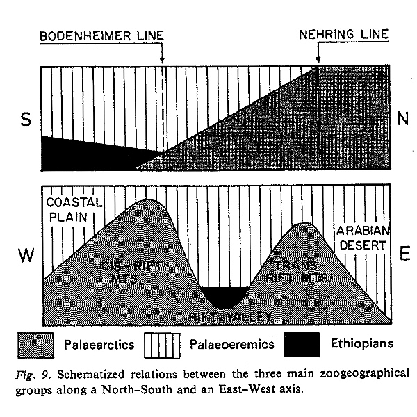 click to enlarge
  click to enlarge
 Near East and Levant
Definitions
Different terms are used to encompass the territory comprises between Mesopotamia and Mediterranean Sea, all these terms include geographical or political areas nested one in the other or adjoining.
Particularly important for the entomologists is the geographical interpretation of the Syria labels in old pinned specimens since, as explained in the following paragraphs, the geographical extension of Syria greatly changed between the end of XIX century and the Syria and Lebanon independence, in 1943.
In the present website I will use the following Geographycal terms: Middle East, Near East and Levant. It is useful to provide an explanations of their geographical meaning:
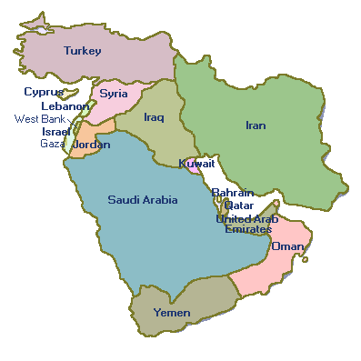
- The Middle East is the geographic region bordering Europe, former USSR, Tropical Asia and Africa and comprises the following countries: Afghanistan, Bahrain, Iran, Iraq, Kuwait, Lebanon, Oman, Palestine, Qatar, Saudi Arabia, Syria, United Arab Emirates and Yemen.
- The Near East refers to the region encompassing Anatolia (the Asian portion of modern Turkey), the Levant (Syria, Jordan, Israel, Lebanon, and Palestine), Georgia, Armenia, and Mesopotamia (Iraq).
- The Levant is an imprecise term referring to an area of cultural habitation rather than to a specific geographic region. It denotes a large area in the Middle East, roughly bounded on the north by the Taurus Mountains, on the south by the Arabian Desert, and on the west by the Mediterranean Sea, while on the east it extends into Upper Mesopotamia; however, some definitions include nearly all of Mesopotamia. The Levant does not include the Caucasus Mountains, or any part of the Arabian Peninsula. The term Levant is somewhat synonymous with the term Mashriq, relating to "the east" or "the sunrise". The Levant in its geographical sense comprises the following political entities: West part of Syria, Lebanon, West part of Jordan, Palestine (West Bank and Gaza Strip), Israel, Sinai (Egypt). From 1920 to 1946 the French Mandates of Syria and Lebanon were called the Levant states. A specific chapter on Levant will describe its peculiarity and zoogeographical meaning.
The Greater Syria
The name of Syria was first given by the Greeks to the city of Tyrus (now Tyre) - Sur in Arabic - and then applied by them to the whole of the province. The term Syria, referring to greater or geographical Syria, began to be used again in the political and administrative literature of the nineteenth century. The Ottoman Empire then established a province of Syria, and more than one newspaper using the term Suriyya in its name was published at the time.
Until World War I the name Syria generally referred to Greater or geographical Syria, which extends from the Taurus Mountains in the north to the Sinai in the south, and between the Mediterranean in the west and the desert in the east.
The French Mandate of Syria was a League of Nations Mandate created after the First World War and the partitioning of the Ottoman Empire. During the two years that followed the end of the war in 1918, and according to the Sykes-Picot Agreement which was signed between Britain and France during the war, the British held control of the Ottoman province of Mesopotamia (Iraq) and the southern part of the Ottoman province of Syria (Palestine and Jordan), while the French controlled the rest of Ottoman Syria (modern Syria, Lebanon, and Hatay province of Turkey).
During the first years of the 1920s, the British and French control of these territories became formalized by the League of Nations' mandate system, and France was assigned the mandate of Syria in September 29, 1923, which included modern Lebanon and Hatay (Alexandretta) in addition to modern Syria.
The French mandate of Syria lasted until 1943, when two independent countries emerged from the mandate period, Syria and Lebanon, in addition to Hatay which had joined Turkey in 1939 following a referendum. French troops fled Syria and Lebanon finally in 1946.
Modified from: Jordan Country Study on Biological Diversity, 1998
Zoogeography of the Levant
The description below is largely taken from Francis D. Por, 1975 - An Outline of the Zoogeography of the Levant. Zoologica Scripta, 4: 5-20. Download full article.
1. Geography
The Levant is the eastern shoreland of the Mediterranean, the north-south branch of the Fertile Crescent,
one of the most ancient cultivated regions of the world. It is a stretch of land about 150 km wide,
wedged in between the sea and the Syrio-Arabian desert, stretching from the mouth of the River Orontes and the
Amanus and Taurus mountain ranges in the north, to the Isthmus of Suez in the south. As such defined, the Levant
measures about 900 km east to west and 530 km north to south. It has an area of approximately 500,000 sq km. Its
lowest point is the surface of the Dead Sea, 1,000 feet (304 m) below sea level. Its highest point is the peak of
Qurnat as Sawda', 3,083 m (10,131 ft) above sea level (see figure: sketch map).
Basically, it consists of four north-south oriented topographical features:
- the coastal plain,
- the western (cis-rift) mountains,
- the rift valley and
- the eastern (trans-rift) mountains.
This longitudinal pattern is especially evident in Israel and Lebanon.
The north-south relief patterns, crossing the zonal climatic belts at right angles, impart an unusual heterogeneity to this relatively small zoogeographic province and set the scene for a highly dynamic faunal history. The tectonic processes which ed to the formation of the rift valley and the mountain ranges east and west of it, are the basic geomorphic features of the Levant province, whereas for the Anatolian province, which borders the Levant in the north, the decisive factor was the alpine folding and for the desert belt bordering it in the south and east, the post-Miocenic desertification was the decisive event.
The longitudinal topographic patterns of the Levant resulted in a considerable deflection of isotherms and isohyets from the latitudinal, zonal pattern (see figure: rainfall map ). Soils and plant communities conform to this pattern. Hydrography is also dominated by a chain of longitudinal north-south river systems.
Although frequented by the first traveling naturalists, starting with Pierre Belon in 1588 and Fredrik Hasselqvist in 1745-1751, the Levantine province has not been analyzed comprehensively from a zoogeographical point of view. The only exception is an early attempt by Bodenheimer (1935, 1937). Kosswig (1955) analyzed the Anatolian fauna and compared it with that of the Levant. He pointed out that the Taurus range forms the division between the two provinces. In several animal groups there were more or less comprehensive attempts at zoogeographic analysis, and the most outstanding are those by Steinitz (1954) on freshwater fishes, by Haas (1952) on reptiles, by Meinertzhagen (1954) on birds, by Harrison (1964, 1968) on mammals, by Etchecopar & Hue (1967) and Hue & Etchecopar (1970) on birds, and by Tchernov on rodents.
2. Climate
Characteristic of the Levant is the large extent of dry Ecological Zones, both desert and sub-desert, with no - or sparse vegetation. Mountains are also extensive and most forests in the region are confined to mountains, in particular the wetter submontane zones. Steppe vegetation, dominated by grass and shrubs, cover the drier mountain zones.
3. A transition area
There are four areas on the globe where the five terrestrial zoogeographic realms come into contact. The Levant province is a nodal point of three faunal regions: Holoarctic, Ethiopian and Oriental. A relatively free transition between the three zones becomes increasingly difficult by the progressive desertification of the intercalated areas. Especially important is the contact in the Levant province between the Palaearctic and Ethiopian faunas. The desert, with its typical fauna, is situated between the two regions. The influence of the Oriental species is sporadic and does not reach a sizeable percentage of the whole fauna but aquatic insects are exceptions in this respect.
4. Terrestrial zoogeography
The first zoogeographical analysis of our area has been given by Bodenheimer (1935, 1937) who based his analysis on 4,346 species, with Orthoptera, Lepidoptera and Coleoptera playing the most important role. For Bodenheimer, �it is not astonishing that plant and animal distribution show a close agreement, since both of them are influenced by-and are a result of-the same environmental factors" (1935, p. 17). The role of the environmental factors in zoogeography is considered today as less important than in phytogeography. In 1937 (p' 23) Bodenheimer further stresses: ".. les aires zoogeoghaphiques coincident avec celles du climat, du sol, de la phytogeographie". Bodenheimer was deeply influenced by his agricultural-entomological background. Eig's classification, maintained with minor modifications to this day by Zohary (1973) and other Israeli botanists, distinguishes five floral provinces in the Levant:
- Euro-Siberian,
- Mediterranean,
- Irano-Turanian,
- Saharo-Sindian (Saharo-Arabian of Zohary), and
- Sudano-Deccanian (Sudanian of Zohary).
These provinces are considered as of equal biogeographical rank. Bodenheimer attempted to integrate them into the system accepted by the zoogeographers, and includes the first four in the Palaearctic, and the last one in the Ethiopian. Today most terrestrial zoologists dealing with Levant do not use the Eig-Bodenheimer system.
The active zoogeographers distinguish four basic faunistic elements:
- Palaearctic,
- Oriental,
- Ethiopian, and
- Palaeo-eremic.
The latter in its sense also includes desert elements which reach farther east than Arabia. The lrano-Turanian element of Bodenheimer includes such desertic elements, apart from steppe-inhabiting Palaearctics. The Mediterranean element is in most of the cases typically Palaearctic. The four above-mentioned faunal elements, the Palaearctic, Palaeo-eremic, Ethiopian and Oriental, are present in most of the animal groups. The relative numerical weight of the four faunal elements depends on the specific ecology and on the capacity of colonization. In most of the animal groups, there is usually a clear prevalence of the Palaearctics. The Ethiopian element is better represented among animals with greater possibilities of colonization, like migrating insects (especially Odonata and Sphingidae), birds, and mammals. The same holds true for the Oriental elements, although they always play the least important role among the four groups.
In the aforementioned groups, which have good abilities of spread and colonization, we also find true "Palaeotropic" species common to both the Ethiopian and Oriental regions; species for which the Palaeo-eremic gap does not function as a barrier. Mention should be made here of an even older tropical element, a true Gondwanian element.
The geographical distribution of the four zoogeographical elements within the Levant province, is as follows: the Palaearctic predominate in the north, and many of them reach their southern limits in Lebanon or in the Northern Galilee. The Palaearctics predominate to the southern foothills of Northern Galilee and the Golan Heights. This is a line that F. D. Por (1975) I propose to call the "Nehring Line" following its first postulation by the mammalogist Nehring (1902). This line has however been set by this author and also by Aharoni (1932), about 50 km further south than the Northern Galilee, namely at the southern foothills of the Carmel ridge and the southern border of the Jezreel valley.
South of the Nehring line, there is a "transitional zone" where Palaearctics mingle with Palaeo-eremic elements. The first still predominate in the cis- and trans-rift mountains and the second reach preeminence in the coastal plain and the Rift Valley. To the south, the transitional zone ends at a line termed by F. D. Por (1975) the "Bodenheimer Line", since it was clearly recognized by Bodenheimer (1935). This line runs from Gaza to Beer Sheba at the foothills of the Judaean Mountains, extends way up north in the Jordan valley and is situated across the Rift, near Petra in the mountains of Moab. South of the Bodenheimer line, there is a solid predominance or even exclusivity of the Palaeo-eremic elements (see figures). East of the Levant proper, in the Syrian desert, many Palaeo-eremics reach far north. North of the Nehring lines, in Lebanon, there are still some Palaeo-eremic elements. South of the Nehring line, there are areas, especially Mount Carmel, where Palaearctics were prevalent at times. South of the Bodenheimer line there are some mountains regions with Holarctic elements: the Ramon Mountains (which may even be considered a southward extension of the Bodenheimer line), some mountain ranges in northern Sinai, and even the high mountains of southern Sinai.
The Ethiopian element does not prevail in any area. It is fairly well represented where humidity is combined with high temperatures. In the valley of the Dead Sea and the Jordan, the Ethiopian species are best represented, especially among insects associated with Acacia (Bytinski-Salz, 1954). Along the coastal plain, the Ethiopian clement was related to swampy regions which are now drained or polluted. The Oriental species are even more scattered, without showing any geographical pattern however avoiding extreme arid conditions. The human agency, with increasing deforestation and agriculture, brought about a certain recent retreat in the Palaearctic arboreal elements and a consequent advance of the open land, desert Palaeo-eremic.
5. Conclusion
- The Levant province is a meeting place and transitional area between the Palaearctic, Oriental and Ethiopian zoogeographic regions. In the marine world, its coasts are inhabited by the temperate Atlantic-Mediterranean fauna and the tropical Indo-Pacific fauna.
- The broad "Palaeo-eremic" desert belt represents a filtering barrier between the three faunal regions. Inhabited by a peculiar fauna of mixed origin, the Palaeo-eremic belt does not belong to any of the above-mentioned regions. The ability to cross the desert barrier differs for the different taxa: it is maximal for mammals, birds and insects, Freshwater fish use a peculiar "steeple chase" waterway connecting the Nile with the Euphrates through the waterways of the Rift valley. The man-made Suez Canal serves as a filtering pathway through which the Indo-Pacific tropical fauna invades the Mediterranean.
- In the terrestrial environments, the transition from the dominance of the Palaearctic species in the north to that of the Palaeo-eremic species in the south is complicated by the fourfold longitudinal geomorphological pattern of the area. Palaearctic species advance south along the cis- and trans-rift mountain ranges, while Palaeo-eremic and Ethiopian species extend northwards along the coastal plain and the Rift valley. The Indo-Pacific emigrants to the Mediterranean advance northwards along the Levant coast, and their influence gradually decreases towards the north.
- The Levant province has suffered the most profound human impact for some 10000 years. Nevertheless, there are some endemic species in the area. These are animals of Palaeo-eremic or Ethiopian character, especially concentrated in the waters and oases of the Rift valley. The wealth of the marginal populations in the zoogeographic ecological, and physiological sense, makes protection of species and habitats especially important.